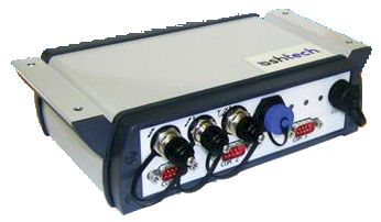
Ashtech ADU800
Real Time, Instantaneous 6D
GNSS Positioning System
Specifications |
|
 |
Ashtech ADU800
Tarifs sur demande
Key Features
- Real time 6D GNSS positioning system
- 3D position up to centimeter level
- 3D attitude information: Heading, Pitch and Roll
- Smart and rugged design for easy integration and demanding environments
- Ashtech Z-Blade®Technology (GNSS-centric engine) for optimal productivity
Fiche technique en anglais.

|
 |
Ashtech has raised the bar on GNSS attitude determination and real-time positioning with the ADU800, a 6D positioning system providing position + orientation for
those who don’t need to simply position a point, but want to position a platform!
The ADU800 is built on the strength of its predecessors, the Ashtech 3DF, ADU1, ADU2 and ADU5 and delivers unsurpassed accuracy in a rugged, full-function system.
ADU800 provides precise heading, pitch and roll along with three-dimensional position up to centimeter-level of accuracy and velocities at a rate of up to 20 Hz for static and dynamic
platforms, making it an ideal solution for a wide variety of airborne, marine and terrestrial applications.
Advanced Features
The ADU800 from Ashtech is a three antenna GNSS system employing “on-the-fl y” integer ambiguity resolution techniques using carrier phase measurements from the three
on board GNSS receivers to provide instantaneous 3D attitude information. Attitude angular accuracies depend on the spatial separation between the three antennas and ADU800 can typically
provide accuracies of 0.1 degree for heading and 0.2 degree for pitch and roll, using a 2 meter antenna separation.
The auto-calibration feature of the antenna setup, while supporting quite arbitrary installation geometry depending on platform limitations, remove the need of external
calibration tools or complex / diffi cult installations.
In addition to the 3D attitude, the main GNSS board of the ADU800 is providing a 3D position up to centimeter-level accuracy in RTK mode when appropriate corrections feed
the receiver.
The ADU800 can be readily used in GNSS applications such as gyrocompass calibration, open-pit mining, dredge positioning, seismic exploration and oceanographic research, airborne videography
and remote sensing, as well as many other terrestrial, marine and airborne weapons and antenna pointing applications.
Easy Integration
The ADU800 is housed in a small, weatherproof, lightweight and rugged enclosure that is built around the GPS/GLONASS/SBAS MB100 and MB800 boards. Embedded Z-Blade™ technology
ensures powerful performance and a patented way to use multiple GNSS constellations. It is fi tted with a built-in power supply extending the input voltage range to between 9 and 36 V DC
while maintaining a low power consumption regardless of the power input voltage.
The ADU800 can be operated in harsh environments while requiring a minimum of space for its installation. As a lightweight unit, the ADU800 is also compatible with airborne
applications for which weight considerations are critical.
ADU800 Technical Specifications*
* Including all available options
GNSS Characteristics
- 210 (120+2*45) channels :
- GPS L1 C/A, L1/L2 P-code, L2C, L5
- GLONASS L1 C/A, L2 C/A code
- GALILEO E1 and E5
- SBAS L1 (WAAS/EGNOS/MSAS/GAGAN)
- QZSS
- Z-Blade technology (Ashtech GNSS centric algorithm) for optimal performance in harsh environment 1
- Quick signal detection engine for fast acquisition and re-acquisition of GNSS signals
- Fast and stable RTK solution + attitude solution
- Up to 20 Hz real-time raw data, position and heading output
- Advanced multi-path mitigation technique
Real-Time Accuracy (HRMS) 2,3
- SBAS (WAAS/EGNOS/MSAS) : < 50 cm (1.64 ft)
- DGPS : 25 cm (0.82 ft) + 1 ppm 4
- RTK : 1 cm (0.033 ft) + 1 ppm 4
- Flying RTK : 5 cm (0.165 ft) + 1 ppm 4 for baselines up to 1000 km
- Velocity Accuracy2 (knots) : 95%: 0.1
Real-Time Attitude Accuracy 5
- 1-meter Antenna Separation
- Heading 0.2° rms
- Pitch/Roll 0.4° rms
- 3-meter Antenna Separation
- Heading 0.06° rms
- Pitch/Roll 0.12° rms
- 10-meter Antenna Separation
- Heading 0.02° rms
- Pitch/Roll 0.04° rms
Real-Time Performance
- Instant-RTK Initialization
- Typically 2-second initialization for baselines < 20 km
- Up to 99.9% reliability (user configurable)
- RTK Initialization range : > 40 km
- Time to First Fix2 :
- Re-acquisition 3 sec
- Hot start 15 sec
- Warm start 35 sec
- Cold start 45 sec
- < 1 minute cold start to fi rst attitude data
RTK Rover
- Up to 20 Hz Fast RTK
- RTCM-2.3 & RTCM-3.1
- CMR & CMR+
- DBEN, LRK & ATOM (Ashtech formats)
- Networks: VRS, FKP, MAC
- NMEA0183 messages output
- RTK with moving base operation
- Heading, pitch and roll determination with auto-calibration
I/O Interface
- 3 RS232
- 1 USB 2.0 port
- 1 PPS output
- 1 Event marker input
- 3 TNC-F antenna connectors
- 5V power output on RS232 pin 9 (h/w jumper)
Physical Characteristics
- Size (WxHxD): 190 x 58 x 160 mm (7.48x2.28x6.3 in) Width sliding bars included: 221.5 mm (8.72 in)
- Weight: 1.4 kg (3.08lb)
Environmental Characteristics
- Operating temperature: -30° to +60°C (-22° to +140°F)
- Storage temperature: -40° to +70°C (-40° to +158°F)
- Humidity: 100% condensing
- IP67
- Shock: MIL-STD 810F, Fig. 516.5-10 (40g, 11ms, saw-tooth)
- Vibration: MIL-STD 810F, Fig. 514.5C-175
- Speed (max): 514 m/sec (1,000 knots)
- Altitude (max): 18287 m (60,000 feet)
Power Characteristics
- 9-36 VDC input
- Protected against over voltage up to 70 Volts and against reverse polarity
- Protected against electrical disturbances of vehicles with 12v and 24V supply voltages (ISO 7637 standard)
- Typical power consumption with 12 VDC input: 5.5W
- GNSS antenna(s) powered from 5 VDC (±10%); DC current: 100 mA max., 5 mA min.
Recommended Antennas
- Compact GNSS Machine/Marine/Aviation Antennas: Trimble AV33 & AV34
- GNSS Machine/Marine/Aviation Antennas: Trimble LV59 & AV59
Configuration Tool
Ashtech Communicator is a GNSS Utility software for sensor evaluation and configuration:
- Preset of commands
- Real time data logging
- Real time data visualization
(1) All the available GNSS signals are processed equally and combined to improve performance in harsh environment.
(2) Accuracy and TTFF specifi cations may be affected by atmospheric conditions, signal multipath, and satellite geometry. Position accuracy specifications
are for horizontal positioning. Vertical error is typically < 2 time’s horizontal error.
(3) Performance values assume minimum of five satellites, following the procedures recommended in the product manual. High multi-path areas, high PDOP values and
periods of severe atmospheric conditions may degrade performance.
(4) Steady state value after suffi cient convergence time.
(5) Typical values for properly installed antenna on vehicle body.
Haut de la Page
GPS Gamme complète
GPS Polyvalents - GPS Aviation - GPS Marine -
GPS Cartographie - Les Logiciels
[GPS Portables et Fixes] [OEM Composants] [Localisation et Suivi de
véhicules] [Applications Professionnelles]
|


