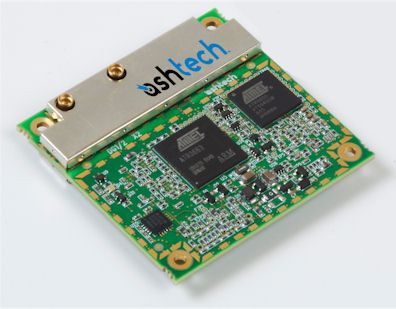
Ashtech MB100
Compact, Low-Power, GPS/GLONASS
RTK OEM Receiver Module
Specifications |
|
 |
GPS OEM MB100
Tarifs sur demande
Key Features
- Heading + Pitch/Roll
- Dual-frequency - GPS+SBAS
- Single-frequency - GPS+GLONASS+SBAS
- L1 RTK and L1/L2 RTK
- Compact design and low-power consumption
- Designed for demanding environments
- New Ashtech Z-Blade Technology :
- GNSS-centric engine
- GLONASS-only capable
Fiche technique en anglais.

|
 |
When power consumption, size and dependable performances such as raw data quality, realtime positioning (SBAS up to RTK) or GNSS Heading + Pitch/Roll determination are critical,
the Ashtech MB100 GNSS board simply delivers!
The MB100 is the only board designed to address L1 GPS+SBAS applications - including Heading + Pitch/Roll determination, L1/L2 GPS+SBAS or L1 GPS/GLONASS+SBAS applications in
the smallest form factor and lowest power consumption available today on the market. Z-Blade Technology and dual-frequency GPS confi guration offer amazing, long-range RTK performance, while
single-frequency GPS + GLONASS confi guration provides more satellites in view for demanding environments.
Ashtech High-End Performance
Embedded Z-Blade GNSS centric technology uses all available GNSS signals equally, without any constellation preference, to deliver fast and stable solutions. This leads to
incredibly robust and dependable measurement processing, resulting in optimized fi eld productivity :
- Advanced multi-path mitigation and signal tracking for maximum data reliability
- Fast initialization and centimeter accuracy at long-range in dual-frequency GPS mode
- Full benefi t of any available GLONASS satellites to strengthen the GPS solution in singlefrequency GPS + GLONASS mode
- The most compact differential/raw data protocol: Ashtech Optimized Messaging (ATOM)
Seamless Integration and Flexibility
The MB100 features low-power consumption in an extremely compact board design and a variety of output messages and data formats for extensive OEM solution interoperability.
The MB100 works as a base, a rover and even a GNSS compass, and is available in various GNSS modes to adapt to customer needs. All GNSS modes are available in the same hardware and are simply
activated by fi rmware option activation.
MB100 supports standard and advanced RTK operations such as :
- RTK against a static base, with or without SBAS and GLONASS satellites
- Advanced RTK against an external moving base for relative positioning
- Network RTK using third-party network corrections: VRS, FKP, MAC
- Heading and pitch or roll determination with baseline length auto-calibration
- Up to 20 Hz fast RTK and raw data output
The MB100 features two antenna input connectors, with automatic switching between the two antennas for specifi c applications such as handheld and tablet PC intergration or
Heading + Pitch/Roll determination - the ideal, low-cost GNSS compass solution!
MB100 GNSS Receiver Module* : Specifications
(*) Including all available options
GNSS Characteristics
- 45 channels :
- GPS and GLONASS L1 C/A,
- GPS L1/L2 P(Y)-code, L2C, L1/L2 full wavelength carrier,
- SBAS (WAAS / EGNOS / MSAS)
- Fully independent code and phase measurements
- Advanced multi-path mitigation
- Z-Blade technology for optimal GNSS performance :
- Ashtech GNSS centric algorithm: fully independent GNSS signal tracking and processing
- Quick signal detection engine for fast acquisition and re-acquisition of GNSS signals
- Fast and stable RTK solution
Features
- Up to 20 Hz Real-time GPS, GLONASS, SBAS raw data (code and carrier) and position output
- Real-time GPS, GLONASS and SBAS sub-frames output
- Ephemeris and almanac for GPS, GLONASS and SBAS output
- Ionosphere data output
- NMEA0183 messages output
- RTK base and rover modes
- Easy-to-use trouble ticket (ATL)
RTK Base
- RTCM-2.3 & RTCM-3.1
- CMR & CMR+
- DBEN & ATOM (Ashtech format)
- Moving base operation
RTK Rover
- Up to 20 Hz Fast RTK
- RTCM-2.3 & RTCM-3.1
- CMR & CMR+
- DBEN, LRK & ATOM (Ashtech formats)
- Networks: VRS, FKP, MAC
- NMEA0183 messages output
- RTK with moving base operation
- Heading and pitch or roll determination with auto-calibration
Accuracy Specifications (RMS) 1
- SBAS : < 50 cm typical Horizontal
- DGPS : < 30 cm + 1 ppm typical Horizontal 2,3
- Flying RTK : 5cm + 1 ppm horizontal (steady state) for baselines up to 1000 km
- RTK :
- Horizontal : 1 cm + 1 ppm 2,3
- Vertical : 2 cm + 1 ppm 2,3
- Heading, Pitch/Roll :
- Heading : 0.2 deg/baseline (m) 2,4
- Pitch/roll: 0.4 deg/baseline (m) 2,4
RTK Initialization
- Range :
- 40 km and more in dual frequency mode
- Up to 10 km typical in single frequency mode
- Time to First Fix 1,6
- Re-acquisition: 3 sec
- Hot start: 11 sec
- Warm start: 35 sec
- Cold start: 45 sec
- Reliability : Up to 99.9% typical (user confi gurable)
I/O Interface
- SAMTEC 26 pins I/O connector (SAMTEC FTS-113-01-F-DV-A (pin out allocation compatible with DG14)
- 1 RS232 up to 921.6 kbits/sec (RxD, TxD, CTS and RTS signals)
- 1 RS232 up to 115.2 kbits/sec (RxD and TxD signals)
- 1 USB 2.0 Device “Serial Port” up to 12Mbits/sec
- 1 PPS output
- 1 Event marker input
- Radar-simulated pulse output on the I/O connector for accurate ground speed
- Onboard LED + output to drive external LED
- Antennas: 2 female MMCX straight connector 5
Physical Characteristics
- Size (WxHxD) : 58x56x11 mm (2.3x2.2x0.4 in)
- Weight : 22g / 0.78oz
Power Characteristics
- Power input : +3.3V DC±10% power input
- Power consumption :
- < 0.8W in GPS L1
- < 0.95W in GPS L1/L2 or GPS+GLONASS L1
- Back-up power : 2.6 to 3.3V DC6
- Antenna(s) LNA power output : +5 VDC (±10%), Max current 100mA, Min current 5mA
Environmental Characteristics
- Operating temperature : -40° to +85°C (-40° to +185°F)
- Storage temperature : -40° to +85°C (-40° to +185°F)
- Humidity : 95% non-condensing
- Shock : MIL-STD 810F, Fig. 516.5-10 (40g, 11ms, saw-tooth)
- Vibration : MIL-STD 810F, Fig. 514.5C-17
Recommended Ashtech Antennas
- L1 GNSS Survey Antenna (38dB gain)
- Compact L1 GNSS Antenna (43dB gain)
- GNSS Survey Antenna (38dB gain)
- GNSS Machine/Marine Antenna (38dB gain)
Configuration Tool
Ashtech Communicator is a GNSS utility for boards and sensors evaluation and confi guration.
- Preset of commands
- Real-time data logging
- Real-time data visualization
(1) Accuracy and TTFF specifi cations may be affected by atmospheric conditions, signal multipath, satellite geometry and corrections availability and quality.
Position accuracy specifi cations are for horizontal positioning. Vertical error is typically < 2 time’s horizontal error.
(2) Performance values assume minimum of fi ve satellites, following the procedures recommended in the product manual. High multipath areas, high PDOP values and periods
of severe atmospheric conditions may degrade performance.
(3) Steady state value for baselines < 50 km after sufficient convergence time.
(4) Typical values for properly installed antenna on vehicle body.
(5) For internal and external active antennas with automatic switch to external antenna when connected or for Heading determination between both antennas.
(6) Back-up battery may be used for RTC (Real Time Clock) to improve hot start TTFF performances.
Haut de la Page
GPS Gamme complète
GPS Polyvalents - GPS Aviation - GPS Marine -
GPS Cartographie - Les Logiciels
[GPS Portables et Fixes] [OEM Composants] [Localisation et Suivi de
véhicules] [Applications Professionnelles]
|


