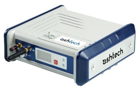
Ashtech HDS800
Flexible, Rugged,
High-Performance GNSS RTK+HeaDing System
Specifications |
|
 |
Ashtech HSD800
Tarifs sur demande
Key Features
- High Performance GNSS Centric Receiver
- Dual Boards System for RTK + Heading & Pitch/Roll
- Highly fl exible
- Designed for demanding environments
Fiche technique en anglais.

|
 |
The HDS800 is a powerful positioning solution that delivers state-of-the-art RTK + Heading measurements in a rugged, highly integrated receiver design.
Embedded Z-Blade GNSS centric technology uses all available GNSS signals equally, without any constellation preference, to deliver fast and stable RTK + Heading solutions.
With over 25 years of fi eld-proven Ashtech GNSS technologies, the HDS800 is made to withstand harsh environments and give you maximum fl exibility in the field.
Z-Blade long-range RTK capability, leading GNSS Heading algorithms and UHF expertise allow you to increase productivity.
- Rugged design for demanding work environments
- Fast initialization and centimeter accuracy at long-range
- Hot-Standby RTK feature automatically selects the best available position
- Dependable Heading + Pitch/Roll measurements with baseline auto-calibration
- Advanced multi-path mitigation and robust signal tracking for maximum data reliability
- Unique Z-Blade technology for outstanding GNSS performance in harsh environments
- Unique built-in communication features, including 3.5G modem and Pacifi c Crest ADL Foundation TRx
The HDS800 is the ideal tool for many types of applications. Bathymetry, dredging or coastal works are some of the Marine applications, while guidance/control
requiring RTK + Heading measurements are appropriate for Machine Control. The HDS800 boosts levels of performance ahead of the most sophisticated equipment available today. Thanks
to its unique design, it can also easily be carried from site to site.
Ashtech High-End Performance
The HDS800 embeds Ashtech Z-Blade Technology, a new GNSS centric signal processing technology that optimally processes all of the available satellite signals,
maximizing your ability to obtain reliable GNSS Position and Heading in the widest variety of conditions. Z-Blade allows you to get and/or maintain RTK + Heading solutions even
if GPS coverage is insuffi cient.
Ruggedness
The innovative design integrates all the communication components (GSM/GPRS and/or UHF radios) offering an all-in-one robust solution to the user. The weatherproof,
high-impactresistant molded aluminum housing, the fl oating power input, the earth terminal and the optical isolation from internal circuitry of all available signals, ensures your
investment is safe in all conditions.
Flexibility
The HDS800 offers a unique design which includes a unique set of built-in communication features, internal and removable battery which acts as an Uninterruptible
Power Supply (UPS) for a power source outage, internal memory expandable through USB key, UHF and GPS aerial kits with low-loss cables, and rugged mounting parts for easy and powerful
installation on-board ships or various machines.
HDS800 GNSS Receiver* : Specifications
* Including all available options
GNSS Characteristics
- 240 (2*120) channels :
- GPS L1 C/A L1/L2 P-code, L2C, L5
- GLONASS L1 C/A, L2 C/A code
- GALILEO E1 and E5 (including GIOVE-A and GIOVE-B test satellites)
- SBAS L1 code and carrier (WAAS/EGNOS/MSAS)
- Fully independent code and phase measurement
- Z-Blade technology for optimal GNSS performance
- Ashtech GNSS centric algorithm: fully independent GNSS signal tracking and processing 1
- Quick signal detection engine for fast acquisition and re-acquisition of GNSS signals
- Fast and stable RTK solution
- Up to 20 Hz real-time raw data , position and heading output
- Advanced multi-path mitigation technique
- RTK base and rovers modes, post-processing
Real-Time Accuracy (RMS) 2,3
- SBAS (WAAS/EGNOS/MSAS) : Horizontal < 50 cm (1.64 ft)
- DGPS : Horizontal: 25 cm (0.82 ft) + 1 ppm 4
- Flying RTK : 5cm + 1 ppm horizontal (steady state) for baselines up to 1000 km
- RTK :
- Horizontal: 1 cm (0.033 ft) + 1 ppm 4
- Vertical: 2 cm (0.065 ft) + 1 ppm 4
- Flying RTK : 5 cm (0.165 ft) + 1 ppm Horizontal for baselines < up to 1000 km
- Heading, Pitch/Roll :
- Heading : 0.2 deg/baseline (m) 5
- Pitch/roll: 0.4 deg/baseline (m) 5
Real-Time Performance
- Instant-RTK Initialization
- Typically 2-second initialization for baselines < 20 km
- Up to 99.9% reliability (user configurable)
- RTK Initialization range : > 40 km
Data Logging Characteristics
- Recording Interval : 0.05 - 999 seconds
- Memory
- 128 MB internal memory
- Ring File Memory function offering unlimited use of the storage medium
- Memory is expandable through external USB sticks or hard drives
- Sessions
- Up to 96 sessions per day
- Embedded RINEX converter
- Enhanced Automatic FTP push function
Embedded RINEX convertor
- RINEX 2.11 and 3.01 are supported
- Converting on-the-fly
- Up to two RINEX fi les with two different rates simultaneously
RTK Base
- RTCM-2.3 & RTCM-3.1
- CMR & CMR+
- ATOM™ & DBEN (proprietary formats)
RTK Rover
- Up to 20 Hz Fast RTK position output
- RTCM-2.3 & RTCM-3.1
- CMR & CMR+
- ATOM, DBEN & LRK (proprietary formats)
- Networks: VRS, FKP, MAC
- NTRIP protocol
- NMEA0183 messages output
Embedded Web Server
- Password-protected Web Server
- Full receiver monitoring and configuration
- FTP push function
- Embedded FTP server and NTRIP caster
- NTRIP Server and instant real-time multi-data streaming over Ethernet
- DHCP or manual confi guration (static IP address)
- DynDNS® technology support
I/O Interface (Rugged, Waterproof Connectors)
- 1 x RS232/RS422 up to 921.6 kbits/sec
- 2 x RS232 up to 115.2 kbits/sec
- USB 2.0 host and device
- Bluetooth 2.0 + EDR Class 2, SPP profile
- Ethernet (Full-Duplex, auto-negotiate 10 Base-TX / 100 Base-TX)
- PPS output
- Event marker inputr
12V/0.5A (1A peak) output available on serial port A
- Optically isolated I/O interface (except USB)
Physical Characteristics
- Size - Unit: 21.5 x 20 x 7.6 cm (8.46x7.87x2.99 in)
- Weight - GNSS receiver : from 2.1 kg (4.6 lb)
Environmental Characteristics
- Operating temperature: -30° to +65°C (-22° to +149°F)
- Storage temperature: -40° to +70°C (-40° to +158°F)
- Humidity: 100% condensing
- IP67 (waterproof and dustproof)
- Salt mist as defi ned in EN60945
- Shock: MIL-STD 810F, Fig. 516.5-10
- Vibration: MIL-STD 810F, Fig. 514.5C-17
Power Characteristics
- Li-ion battery, 32.5Wh (7.4Vx4.4Ah). Acts as a UPS in case of a power source outage
- Battery life time: > 6 hours @20°C (68°F) with UHF rover confi guration (w/o heading)
- 9-36 VDC input (Reverse polarity protected)
- Typical power consumption with 1 GNSS antenna: < 5W
- Supporting transient voltage according to EN2282 with 28V input voltage
- Programmable sleep mode
- External DC power limits feature
Certifications
- n R&TTE directive compliance (CE)
- n FCC/IC
Complementary System Components
- Internal UHF Kits : Pacific Crest Tx/Rx ADL Foundation
- External UHF transceiver Kits : Pacific Crest Tx/Rx
- Built-in 3.5 G Modem
- UMTS/HxDPA: 2100,1900,850MHz; Tri-Band
- GSM/GPRS/EDGE: 850,900,1800,1900,2100 MHz; Quad-Band
- GPRS/EDGE multislot class 12
- Automatic detection 2G-3G
- GCF and PTCRB approved
- Antennas
- Geodetic: GNSS Survey antenna, 38dB gain
- Onboard: GNSS Machine / Marine antenna, 38dB gain
(1) All the available GNSS signals are processed equally and combined performance in harsh environment.
(2) Accuracy and TTFF specifications may be affected by atmospheric conditions, signal multipath, and satellite geometry. Position accuracy specifications
are for horizontal positioning. Vertical error is typically < times horizontal error
(3) Performance values assume minimum of five satellites, following the procedures recommended in the product manual. High multi-path areas, high PDOP values
and periods of severe atmospheric conditions may degrade performance.
(4) Steady state value after sufficient convergence time.
(5) Typical values for properly installed antenna on vehicle body.
Haut de la Page
GPS Gamme complète
GPS Polyvalents - GPS Aviation - GPS Marine -
GPS Cartographie - Les Logiciels
[GPS Portables et Fixes] [OEM Composants] [Localisation et Suivi de
véhicules] [Applications Professionnelles]
|


